
The insurance industry’s conventional method for assessing wildfire risk is profoundly misaligned with reality, as it continues to prioritize the probability of a fire starting over the crucial physical and environmental conditions that permit an ignition to erupt into an uncontrollable, resource-overwhelming conflagration. This deeply ingrained focus on the spark rather than the fuel overlooks the core driver of catastrophic losses: the landscape’s intrinsic ability to sustain and accelerate a fire beyond the point of human suppression. A modern, physics-based assessment reveals that the most significant danger is not determined by where a fire might ignite, but whether the surrounding environment will allow it to become an unstoppable force. This fundamental distinction carries profound implications for countless homeowners, the stability of the insurance market, and the very future of community resilience in fire-prone regions across the nation.
The Decisive Role of Landscape Physics
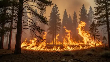
The stark difference between a containable blaze and a devastating wildfire was vividly illustrated through a detailed analysis of several hypothetical Los Angeles fires in January 2025, which all ignited under severe Santa Ana wind conditions. Two of these incidents, the Palisades and Eaton fires, evolved into catastrophic events, collectively destroying over 16,000 structures and causing immense devastation. The reason for their extreme behavior was not mere chance but a direct consequence of the underlying landscape physics. Both fires originated in areas defined by large, continuous blocks of fuel situated in steep, rugged terrain that was exceptionally difficult for firefighting crews to access. This vegetation had not experienced a fire in decades, resulting in mature, dense growth that produced a massive volume of embers—a primary driver of rapid and unpredictable fire spread. This lethal combination of dense fuel, challenging topography, and immense ember output created the perfect conditions for the fires to rapidly expand their perimeters, overwhelming initial attack efforts and building an unstoppable momentum that swept through communities.
In stark contrast to these disasters, the Sunset fire, which started nearby under almost identical weather patterns, was successfully contained within hours after burning only 40 acres. Its divergent outcome was a direct result of the landscape it encountered, which was inherently less conducive to rapid escalation. The fire’s path was consistently interrupted by fragmented patches of fuel, preventing it from building a sustained, unified front that could generate its own weather and momentum. Furthermore, a higher density of roads in the area provided firefighters with superior access, allowing them to attack the flames from multiple strategic points and effectively halt its progress. This case demonstrates unequivocally that the critical variable for risk assessment is not whether a fire will start, but whether the landscape will permit it to become uncontrollable. This principle was further reinforced by two additional incidents in Los Angeles County, the Kenneth and Hurst fires. Both ignited under dangerous conditions but resulted in zero structural losses because they burned through landscapes that had experienced fires within the last two decades, significantly reducing fuel loads and limiting their potential for catastrophic growth.
A New Paradigm for Risk Assessment
The glaring inconsistencies in fire outcomes expose significant gaps in traditional wildfire risk models, which frequently rely on historical burn patterns, ignition probability statistics, or isolated property-level characteristics as primary indicators of danger. These methods are ultimately just proxies that fail to capture the operational fundamentals of fire behavior and spread. An effective, modern model must pivot away from these outdated metrics and instead focus on a comprehensive, physics-based assessment. Such an approach integrates the key variables that truly dictate a fire’s potential for destruction: the structure, density, and continuity of fuel; the complex dynamics of ember generation and long-distance travel; the critical alignment of wind with terrain features like canyons and ridges; and a realistic evaluation of firefighter access and the feasibility of suppression tactics under extreme conditions. By distinguishing between fires that are merely dangerous and those that possess the potential to become truly catastrophic, this sophisticated approach provides a far more accurate and actionable picture of genuine risk.
This shift toward a physics-based framework represents a fundamental redefinition of how risk is understood and managed within the insurance industry. Rather than painting entire regions with a broad brush based on historical data, this nuanced methodology allows for a granular assessment that can identify specific landscape features contributing to elevated risk. For example, a home situated near a recently burned area with low fuel continuity poses a significantly lower threat than a home adjacent to an unburned, steep canyon filled with dense vegetation, even if both are in the same zip code. This level of detail is crucial for accurate underwriting and for empowering homeowners with targeted mitigation strategies. By focusing on the physical mechanics of how fires grow and spread, insurers can move beyond a reactive stance based on past events and adopt a proactive, predictive approach that better reflects the complex, dynamic nature of modern wildfire threats, ultimately leading to more stable and equitable insurance markets.
Forging a Path Toward Resilience
Adopting a more precise, physics-based model for wildfire risk has profound implications that extend beyond underwriting accuracy to the very stability and accessibility of the entire insurance market. A significant number of properties currently deemed uninsurable by the private market may be misclassified due to the limitations of prevailing risk models. An in-depth analysis suggests that approximately 50% of properties currently insured through California’s FAIR Plan—the state’s insurer of last resort—could potentially qualify for coverage in the competitive private market if they were assessed with a more precise, physics-based model. This transformative shift could expand insurance availability to hundreds of thousands of homeowners, significantly reduce the financial and operational burden on public backstops, and help restore functionality to a market that has been under severe strain from escalating wildfire losses. Such a change would not only benefit individual policyholders but would also foster a more resilient and sustainable insurance ecosystem capable of navigating the challenges of a changing climate.
This new understanding of risk also reframes the conversation around mitigation and structure hardening, emphasizing that the effectiveness of such measures is highly dependent on the specific context of a property’s location. In high-risk communities within the wildland-urban interface, particularly those adjacent to large, continuous blocks of fuel, structure-to-structure fire spread often becomes the dominant driver of loss once a wildfire reaches a certain scale. In these intense scenarios, the protective value of hardening an individual property is diminished if the surrounding homes are vulnerable. Here, “edge properties” play a disproportionately critical role; well-hardened homes on the perimeter of a community can act as a crucial buffer, interrupting ember-driven ignition chains and protecting the neighborhood behind them. Conversely, for properties in moderate-risk environments or lower-density developments, comprehensive structure-level mitigation—such as installing screened vents, guarded gutters, enclosed eaves, and noncombustible ground coverings—demonstrates the highest return on investment. A forward-looking, physics-based understanding of wildfire behavior is therefore essential for sustainable insurance underwriting, expanding market access, and creating more resilient communities.